
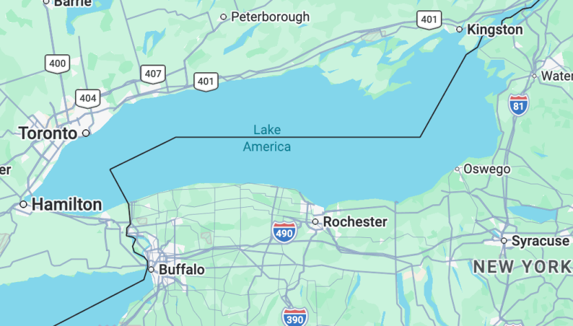
Google Maps Currently Displays ‘Lake America’ in Place of Lake Ontario

Google Maps Currently Displays ‘Lake America’ in Place of Lake Ontario

Lake Ontario is now referred to as “Lake America” on Google Maps in the United States. Late Saturday, Google changed the designation of this eastern Great Lake, following President Donald Trump’s recent order for a change in official documentation.

The executive action issued by Trump on Thursday arose from a trade dispute regarding tariffs with Canada, whose capital province is also named Ontario. In a comparable incident in January 2025, Trump instructed that the Gulf of Mexico be renamed the Gulf of America amidst a disagreement with a southern trade ally.

Firms such as Google, Apple, and Microsoft modified their databases to show Gulf of America once the US Department of the Interior updated its information, reflecting the trend seen after Trump’s latest directive. Therefore, when official data—which informs navigation and formal documents—recognized Lake America, Google’s mapping services adopted the new title.

Other platforms like Apple Maps and Bing Maps have yet to implement this change but are anticipated to follow. Even the Geographic Names Information System database’s map, which dictates such updates, still identified Lake Ontario on Sunday morning but indicated that changes are on the horizon.

Although entities like Google are not legally mandated to utilize official titles, they typically conform to resources such as GNIS. The names displayed on maps are contingent on the user’s geographical location.

In a statement, Google stated, “Users in the US will observe ‘Lake America,’ Canadians will see ‘Lake Ontario,’ and outside these nations, both names will be visible.” They also remarked, “These updates are consistent with our policy on region-specific designations for water bodies and are in the process of being implemented.”

Trump’s effort to modify maps has ignited significant dialogue among open-source mapping communities like OpenStreetMap, which supports businesses such as Uber and Lyft. OpenStreetMap recognizes both US and global designations, enabling organizations to select which name to display.

Conversely, MapQuest has announced it will not follow the changes, declaring on social media, “we’re not changing it,” in response to Trump’s directive.
New Satellite Photos Uncover Devastation from Venezuela Earthquake

New Satellite Photos Uncover Devastation from Venezuela Earthquake

Satellite technology is being leveraged to improve rescue missions in Venezuela following the twin earthquakes that occurred on June 24. Space agencies have supplied images to emergency authorities and the Venezuelan government, emphasizing the scale of the disaster and aiding response teams in directing their efforts and comprehending challenges on the scene.

In the wake of the earthquakes in Venezuela, the Copernicus satellite system has engaged its emergency mapping mode at the request of the European Commission’s Directorate-General for Civil Protection and Humanitarian Aid Operations. Using imagery from Sentinel satellites and sensors, the system has generated 10 products and 25 maps that facilitate real-time evaluation of the damage extent and changes in terrain across 13 areas of interest. These resources also assist officials in pinpointing clear areas for aircraft participating in rescue and aid distribution efforts.

Preliminary data from Copernicus indicates significant damage in La Guaira and Greater Caracas, impacting communities in Aragua, Carabobo, Falcón, and Miranda. As of June 27, around 1,300 structures in the area have been affected.

NASA has mobilized its Disaster Response Coordination System to create maps illustrating how the earthquakes altered the Earth’s surface utilizing data from the NISAR mission, offering crucial insights for emergency managers and scientists.

This effort encompasses a pilot project in collaboration with Copernicus, employing radar images taken by the Sentinel-1 satellite before and after the earthquakes to assess regions highlighted by the European system.

Iranians Do Not Have Missile Alert System, Thus Volunteers Develop Their Own Warning Map

Iranians Do Not Have Missile Alert System, Thus Volunteers Develop Their Own Warning Map

Since the beginning of Donald Trump’s confrontation with Iran more than three weeks ago, U.S. military forces have allegedly targeted upwards of 9,000 locations, creating an atmosphere of fear and uncertainty among Iranians in Tehran and across the country. With no governmental warning system in place and amidst Iran’s longest internet blackout, Iranians are confronted with a lack of information.

Even before the airstrikes by Israel and the U.S., the lack of a public emergency alert system and strict state-controlled digital censorship adversely affected millions. Following last year’s 12-day conflict between Israel and Iran, Iranian digital rights advocates launched ‘Mahsa Alert,’ an innovative platform that delivers push notifications regarding warnings of Israeli assaults, confirmed target areas, and offline mapping capabilities. While it does not serve as a substitute for a coordinated emergency service, this tool aids citizens in critical moments.

“There is no emergency alert system in Iran,” asserts Ahmad Ahmadian, CEO of Holistic Resilience, the U.S.-based organization supporting Mahsa Alert. Established last summer, the platform addresses a vital need by charting Iran’s landscape of repression and surveillance. Lightweight applications for Android and iOS have been developed for offline functionality, essential due to Iran’s internet restrictions. Updates are minimal; a recent one was only 60 kilobytes.

Mahsa Alert features overlays of verified “confirmed attacks” through videos or images provided via a Telegram bot or social networks. Alerts regarding evacuation zones, “danger areas,” and potential hazards to nuclear or military sites keep the public informed. Ahmadian notes that most confirmed attacks correspond with pre-identified map locations.

The platform also catalogs CCTV, government checkpoints, medical facilities, religious locations, protest sites, and more. Mahsa Alert’s visibility internationally has increased on social media, encouraging users to disseminate its findings, resulting in over 100,000 daily active users in a brief period. Roughly 335,000 individuals have utilized it this year, with 28% reportedly from within Iran, particularly during January’s crackdown on demonstrators.